• español
    • English
    • français
    • português
  • português 
    • español
    • English
    • français
    • português
  • Login
View Item 
  •   REPOSITORY SEGEMAR
  • Productos SEGEMAR
  • Geología Regional
  • Escala 1:200.000
  • View Item
  •   REPOSITORY SEGEMAR
  • Productos SEGEMAR
  • Geología Regional
  • Escala 1:200.000
  • View Item
JavaScript is disabled for your browser. Some features of this site may not work without it.

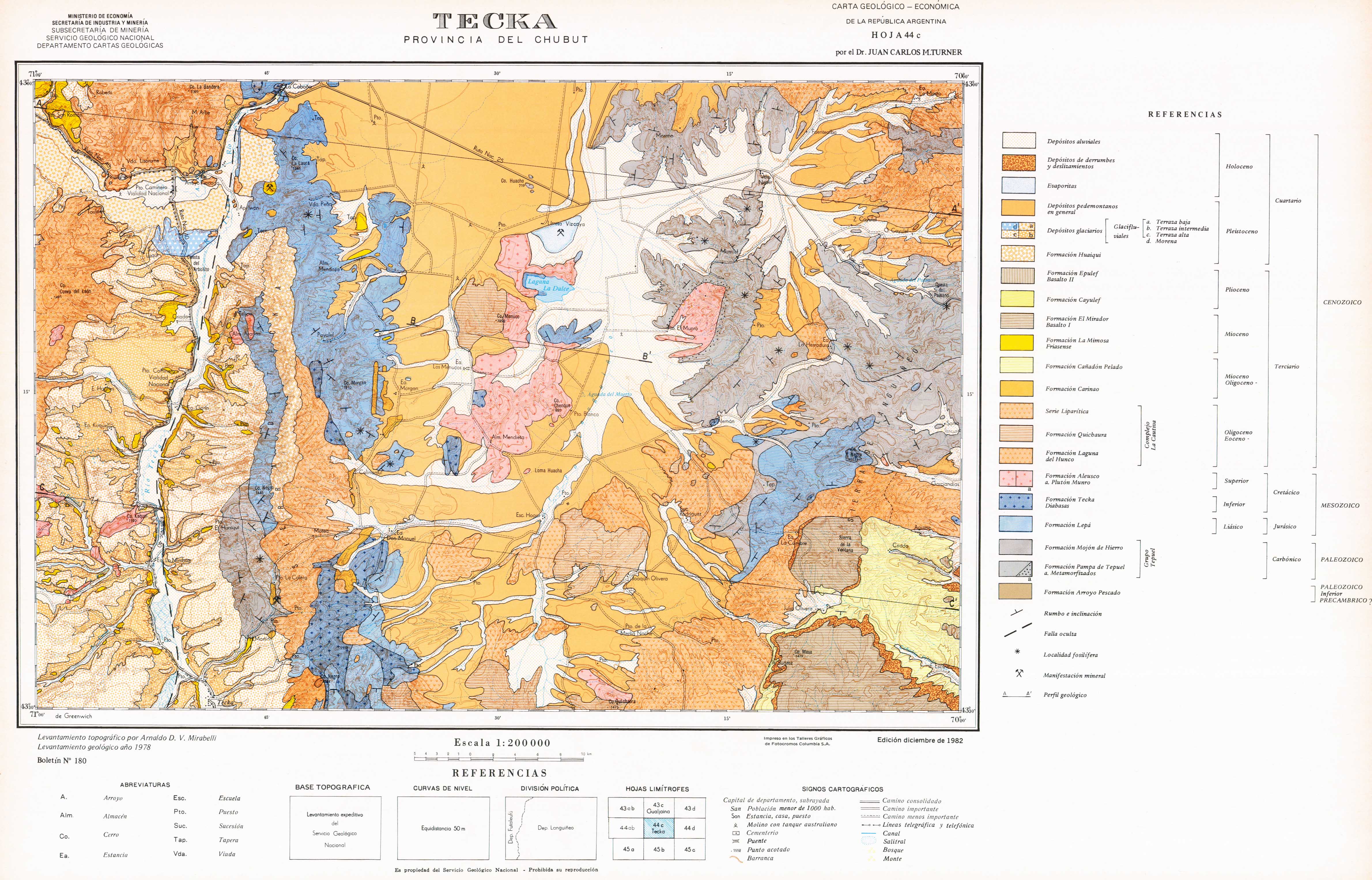
Descripción Geológica de la Hoja 44c, Tecka

Thumbnail
View/Open
imagen001.TIF.thumb.jpg (11.60Kb)
imagen002.TIF.thumb.jpg (25.83Kb)
imagen003.TIF.thumb.jpg (23.43Kb)
44c-TECKA.jpg (1.698Mb)
Tecka.pdf (39.31Mb)
imagen001.TIF (84.27Mb)
imagen002.TIF (88.83Mb)
imagen003.TIF (36.35Mb)
Date
1982
Author
Turner, Juan Carlos Manuel
Metadata
Show full item record
xmlui.dri2xhtml.METS-1.0.item-citation
TURNER, J.C.M., 1982. Descripción Geológica de la Hoja 44 c, Tecka. Provincia del Chubut. Carta Geológico-Económica de la República Argentina. Escala 1:200.000. (Convenio Universidad de Buenos Aires - Secretaría de Estado de Minería). Boletín 180, 90 p. Buenos Aires, Servicio Geológico Nacional.

Fil: Turner, Juan Carlos M. Ministerio de Economía. Secretaría de Minería. Servicio Geológico Nacional y Servicio Minero Nacional; Argentina.

URI
http://repositorio.segemar.gov.ar/308849217/474
Collections
  • Boletines [398]
  • Escala 1:200.000 [128]
  • Hojas Geológicas [342]

SEGEMAR copyright © 2019  REPOSITORIO-DSPACE
Contact Us | Send Feedback
Tel:(+5411) 5670-0100SEGEMAR 
Tel:(+5411) 5670-0101


Browse

All of Repository SEGEMARCollection & CollectionsBy Issue DateAuthorsTitlesSubjectsThis CollectionBy Issue DateAuthorsTitlesSubjects

My Account

LoginRegister

SEGEMAR copyright © 2019  REPOSITORIO-DSPACE
Contact Us | Send Feedback
Tel:(+5411) 5670-0100SEGEMAR 
Tel:(+5411) 5670-0101